Summer in Bolzano and Surroundings: One-of-a-Kind Hikes and Trails
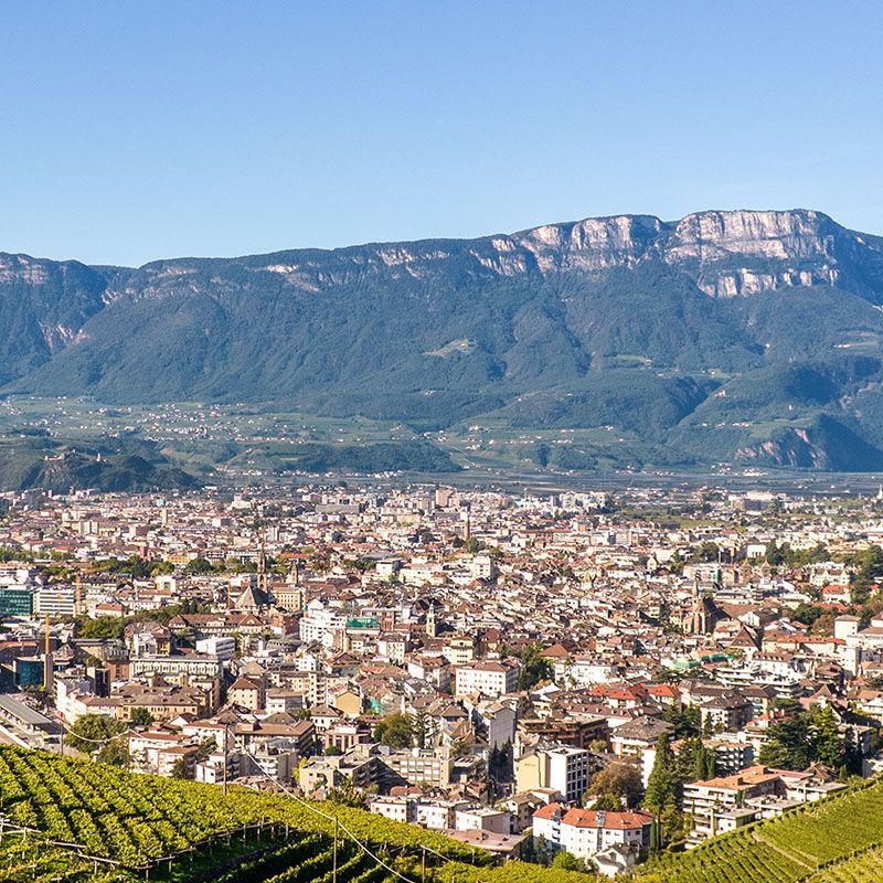
Bolzano, nestled between vineyards and Dolomite peaks, is the perfect launchpad for a summer on the move. Just outside the city, fairytale landscapes unfold—shady woods, flower-strewn pastures, ancient legends, and views that take your breath away. Whether you’re an experienced hiker or a fan of leisurely strolls, the hikes around Bolzano lead you into a world where nature, culture, and tradition weave together at every step.
Talvera Riverside and Sant’Osvaldo Promenades: A Dive into Bolzano’s Beauty
Start from Via Museo and, once you reach Ponte Talvera, turn right: you’ll immediately find yourself in a green oasis of flower beds, subtropical plants, and ancient trees. The Passeggiata Lungo Talvera runs gently beside the river and, after just 400 meters, offers one of Bolzano’s most iconic views: Castel Mareccio framed by vineyards, and in the background the Dolomiti del Catinaccio–Rosengarten with the Torri del Vajolet soaring into the sky. A sight worth a pause!
In 15–20 minutes you’ll reach the end of the promenade (1,300 meters in total). Here, a short detour leads to Castel Sant’Antonio–Klobenstein. If you have a couple of hours to spare, continue toward the Val Sarentino: in just over 15 minutes on foot you’ll arrive at Castel Roncolo, perched on a porphyry spur. The castle, open to visitors from March to November, houses extraordinary secular Gothic frescoes, among the most beautiful in South Tyrol.
If you prefer to stay nearby, from Castel Sant’Antonio you can descend about 30 meters to join the Passeggiata di Sant’Osvaldo. This begins as a peaceful, slightly uphill zigzag path with benches to stop and admire Bolzano from above. After half an hour you’ll reach a junction:
- To the left, about 20 minutes bring you to the Peter Ploner inn, ideal for a tasty break.
- To the right, the path slopes gently back toward the city center.
- Continuing straight, in about half an hour you’ll reach Hotel Eberle and then the wine village of Santa Maddalena, with its little frescoed church from 1370, open to visitors.
From Santa Maddalena, a scenic carriage road takes you comfortably back to the center, passing the “Gatto Nero” inn.
- Best season: Spring and autumn, though the route is walkable year-round
- Insider tip: From March to May, let yourself be enchanted by the spectacular apple blossom
- Elevation gain: About 140 meters
- Hiking time: From 2 hours to half a day (including a visit to Castel Roncolo)
Archduke Heinrich – Guncina Promenade: A Botanical Garden Suspended Over Bolzano
Your adventure begins at Piazza Gries, in the heart of the historic quarter of the same name. Here stands the Benedictine Abbey of Muri-Gries, a monumental complex featuring the splendid Church of Sant’Agostino, decorated with late-Baroque frescoes by Martin Knoller.
A short distance away, along Via Michael Pacher, you’ll find the evocative Church of Our Lady, a late-Gothic masterpiece famed for its winged wooden altarpiece by the renowned artist Michael Pacher, created between 1471 and 1475—one of South Tyrol’s most precious works of sacred art.
Once on the Archduke Heinrich Promenade, inaugurated in 1892 at the behest of Archduke Heinrich of Habsburg, a passionate botanist, you’ll be immersed in an open-air botanical garden. Thanks to the mild microclimate and the porphyry’s heat-retaining properties, plants unusual for these latitudes thrive here: agaves, prickly pear cacti, myrtle, bitter orange, olive, cork oak, and strawberry tree, to name a few.
Along the gentle, never too demanding ascent, you’ll find panoramic benches with spectacular views of Bolzano, Latemar, and the Catinaccio–Rosengarten.
After about 45–50 minutes, you reach the provincial road to San Genesio. Cross it and in another 10 minutes you arrive at Castel Guncina, now an elegant hotel-restaurant—perfect for a break or lunch with a view.
For the return, we recommend an equally scenic alternative: cross the Rio Fago gorge, where a hidden waterfall offers a refreshing interlude. Reaching Via Miramonti, you can admire the evocative cylindrical tower of Trojenstein–Druso.
Finally, follow Via Cadorna and pass near the Rastbichler restaurant to reconnect with the city center and return to the Talvera Riverside Promenades, ending this little journey through nature, history, and beauty on a high note.
- Best season: Spring and autumn, but it’s a lovely walk in every season.
- Insider tip: March and April are ideal to admire the blossom of exotic and Mediterranean plants along the route.
- Elevation gain: About 200 meters
- Hiking time: About 2 hours
Hike from Bolzano to Tschaufen: Meadows, Forests, and Jaw-Dropping Views
From Bolzano’s historic center, you can reach the San Genesio cable car valley station in about 20 minutes on foot by following the Passeggiata Lungo Talvera to the Sant’Antonio bridge. Alternatively, take city buses no. 12 or 14.
In just 8 minutes by cable car, gliding over vineyards, farmsteads, and little ancient churches like San Giacomo and San Giorgio, you’ll reach the plateau at San Genesio (1,087 m), with an unrivaled view of Castel Roncolo and the surrounding mountains.
From the Church of San Genesio, follow the E waymark (Edelweiß) along a carriage road for about an hour to the welcoming Stella Alpina – Edelweiß hotel-restaurant (1,350 m). From here, take trail no. 7 toward Tschaufen; if you have more time, we recommend a detour along the European trail E5 to the Lavenna inn (1,527 m), beside the charming little Church of San Giacomo.
Here, in absolute quiet, you can enjoy one of the most moving panoramas on the plateau, framed by alpine flowers. After a refreshing break, retrace your steps to the junction for Tschaufen (trail 7B), which crosses meadows and woods in about 45 minutes.
For the return, take trail no. 2 eastward, passing the Guggen farm; in 40 minutes you’ll arrive at the characteristic Wieser farm-inn (1,400 m), perfect for another tasty stop. Just below, you can admire the earth pyramids formed by a major landslide—a true geological surprise!
Continuing along trail no. 2, you’ll pass a old mill and a commemorative wayside shrine recalling the 1797 battle against the French. After about one hour you’ll reach the upper cable car station again, wrapping up a varied and satisfying hike.
- Best season: Spring (for the bloom) and autumn (for the warm colors of the landscape)
- Insider tip: May and June are perfect to admire the alpine bloom at its best.
- Highest point: 1,450 m (with Lavenna variant: 1,527 m)
- Elevation gain: Without variant 360 m / With Lavenna variant 440 m
- Hiking time: About 4.5 hours (base route) / 6.5–7 hours (with Lavenna variant)
Discovering the Renon Earth Pyramids: A Hike of Nature and Wonder
The hike begins with one of the most spectacular experiences around Bolzano: the Renon cable car, which in a swift “flight” carries you from Bolzano to Soprabolzano (1,220 m). The panorama over the valley floor and the Dolomite peaks is breathtaking.
Right outside the upper station, hop aboard the Renon narrow-gauge train, a romantic, old-time ride that passes through woods, little lakes, and small villages. In about 20 minutes, passing the little lake of Costalovara and the hamlet of Stella, you’ll reach Collalbo (1,215 m).
From Collalbo, follow waymark no. 1 toward Corno del Renon. Shortly afterward, you’ll cross the carriage road to Auna di Sopra: take trail no. 1A, which leads among streams, farmhouses, and green pastures to the provincial road near the Sport Hotel Spögler.
In the warmer months (May to October), this variant is ideal for immersing yourself in nature’s quiet. Alternatively, you can follow the paved road through Collalbo and Longomoso.
Following an old Way of the Cross, you’ll reach the hamlet of Maria Saal (1,174 m) in about 1 hour 15 minutes, dominated by a picturesque baroque little church. A stop at the nearby inn is a must to recharge.
For the return, you can follow the outward route or opt for a scenic little path descending near the Husch farm, skirting the ridge of the ravine and offering a close-up view of the Earth Pyramids. Along the way, you’ll come across a flat boulder with deep grooves that some studies suggest may be a stretch of the ancient Roman road to the Brenner Pass.
Once back near the Sport Hotel Spögler, cross Longomoso (home to a former hospice of the Teutonic Order) and return to Collalbo. From here, it’s just 20 minutes to the train station.
Still have energy? You can extend the hike with two easy, panoramic options: walk to Soprabolzano along a comfortable path through pine woods and clearings (1–1.5 hours), or take the
level walk around Monte Fenn, between Collalbo and Longomoso (1–1.5 hours round trip).
- Best season: From April to November
- Insider tip: May and June during the alpine bloom deliver unforgettable scenes.
- Elevation gain: None, a route suitable even for less experienced walkers
- Hiking time: 2.5–3 hours (main route only)
From the Heart of Bolzano to the Summit of Corno del Renon: A Hike Between Sky and Dolomites
Your adventure starts in Bolzano, where in just a few minutes you’ll board the modern Renon cable car: an exciting ride up to Soprabolzano (1,220 m) with unique views of the valley and the Dolomite peaks.
Right in front of the upper station, take trail no. 6, which climbs gently through the village before entering greenery.
As the houses fall away, nature takes over. The ascent crosses the Gstrahl meadows (1,361 m) and reaches the small biotope of Riggermoos, a true natural treasure.
After crossing a carriage road, continue on trail no. 6 to Restaurant Tann (1,488 m). From here, in 20 minutes, you’ll reach the Pemmern hotel-restaurant (1,538 m), the starting point of the chairlift to higher ground.
About 20 minutes by chairlift bring you to Cima Lago Nero (2,070 m). From here, another 20 minutes along trail no. 1 lead to the Corno del Renon hut (2,044 m). But don’t stop here!
Continue for 45 minutes through pastures and alpine meadows to the summit hut (2,260 m) and get ready to be amazed: a 360° panorama opens from Monte Bondone to the Adamello and Presanella glaciers, from the Ortles group to the Großglockner, all the way to the Marmolada and the Rosengarten–Catinaccio.
After a well-earned break (perhaps with a hearty local dish), descend to the Lower Corno del Renon hut and follow trail no. 1 toward the Auf der Schön alp. Here, every year on 24 August, St. Bartholomew is celebrated with a big country festival, showcasing the area’s finest livestock.
Crossing green pastures, return to Pemmern (1 hour), from where you can take a bus back to Collalbo (20 minutes). To round off the day in style, board the Renon narrow-gauge train for a leisurely ride to Soprabolzano, then descend to Bolzano by cable car.
Important: before setting off, check the timetables for bus, train, and cable car.
- Best season: From Pentecost to October
- Insider tip: June and July are perfect to admire the alpine flora in bloom
- Highest point: Corno del Renon – 2,260 m
- Elevation change: Ascent 409 m / Descent 723 m
- Hiking time: About 4.5 hours (without using bus, chairlift, or train)
Exploring Colle: From the Heart of Bolzano to the Cool of the Forests
The starting point is the Colle cable car valley station, easily reached by city bus no. 11. This isn’t just any cable car: inaugurated in 1908, it was the world’s first cableway built for passenger transport. A true piece of history!
In a few minutes you’ll rise to 1,135 m, where a 36-meter-high wooden panoramic tower awaits. From the top you can enjoy unbeatable views of Bolzano, the Adige Valley, and the surrounding mountain crown.
Have a few extra hours? Don’t miss the chance to explore these beautiful forests. Follow trail no. 1 to reach the Schneiderwiesen inn in about 30 minutes, ideal for a restorative stop. From here, continue along the “i” trail to Klaus alpine hut (another 30–45 minutes).
After a short detour to Wolftal alp (Valle di Lupo), take trail no. 4 (E5 – European long-distance path) to the Colle dei Signori, where you’ll find the little Church of St. Mary of the Assumption (1,181 m).
Now follow the R Röllhof waymark: in about 30 minutes you’ll reach the Röllhof inn (942 m), surrounded by pine woods. The route continues on a paved stretch and joins a tarmac lane leading to the Kofler inn. Not far away stands Castel Campegno, unfortunately not open to visitors, but still evocative.
Climbing slightly along the S waymark, you’ll reach the località Campegno and the little Church of St. Anna, a tiny gem of tranquility (10 min).
The path continues with gentle ups and downs through coppice woodland and passes under the cable car. Shortly before the Kohlerhof inn (40 min), a fork allows you to return to the valley station in 20 minutes. Alternatively, you can continue toward the Virgolo and visit the evocative Baroque Church of Calvary.
To complete the hike, descend into town along a former Way of the Cross, passing Viale Trento, Ponte Loreto, and Piazza Verdi (around 30 min).
- Best season: From March to November
- Insider tip: An ideal route in the summer months thanks to the forest shade. In autumn, the hike turns into a “Törggelen” experience: chestnuts, new wine, and classic South Tyrolean vibes.
- Highest point: Colle dei Signori – 1,181 m (with Klaus alp variant: 1,528 m)
- Elevation change: Ascent 46 m / Descent 916 m (without Klaus variant)
- Hiking time: Without variant 3–3.5 hours / With Klaus alp variant up to 5 hours
Hike to Missiano and the Castles of the Oltradige: A Journey into the Middle Ages
Keen for an adventure among castles, vineyards, and fairytale views? Set off from Bolzano to discover Castel d’Appiano, Castel Boymont, and Castel Corba, three gems set among the hills of the Oltradige. An easy yet enchanting hike—perfect for a half-day out.
Simply hop on a local bus toward Missiano to step straight into a timeless atmosphere. Just outside the city, by the Adige Bridge, you can admire Castel Firmiano (Sigmundskron) dominating the Bolzano basin: a true symbol of South Tyrol alongside Castel Tirolo.
After passing Cornaiano and San Michele di Appiano, the bus stops at San Paolo and finally Missiano, where the walking route begins.
From Missiano, follow trail no. 9, gently climbing among neat vineyards and fragrant woodland to Castel d’Appiano – Schloß Hocheppan (630 m), reached in about 1 hour. This fascinating 12th-century stronghold was built by the Counts of Appiano and houses a small little chapel entirely frescoed with secular and religious scenes, including the extraordinary cycle of the Wise and Foolish Virgins.
From the castle’s viewpoint, the vista opens over the Adige Valley and surrounding hills. From April to November, the castle is open to visitors and also offers a small eatery.
Continue along trail no. 9A, descending into a small gorge before climbing the opposite side (with some stair-equipped sections). In about 45 minutes you’ll reach the ruins of Castel Boymont, dating to the 13th century. Its panoramic tower affords magnificent views, while in the inner courtyard you can enjoy local fare.
The route continues on an easy carriage road to Castel Corba (Schloss Korb), now an elegant hotel residence built into a massive medieval tower. All around, historic residences and ancient manors tell of a noble, fascinating past.
After exploring Castel Corba, take Via Nußbaumer; in about 30 minutes you’ll reach San Paolo, where you can catch the bus back to Bolzano.
- Best season: From March to November
- Insider tip: In mid-April the apple blossom turns the valley into a sea of white petals—unmissable!
- Highest point: Castel d’Appiano – 630 m
- Elevation gain: 242 m
- Hiking time: 2.5–3 hours
Hike from Bolzano to the Ice Holes: Nature, History, and Natural Wonders
From Bolzano, a local bus takes you easily to San Michele di Appiano (411 m). From the stop in Piazza dei Domenicani, set off on foot toward Piazza Municipio, passing the Parish Church and skirting the ice stadium until you join the Gleif Promenade, a quiet route through mixed conifer and broadleaf woodland.
In about 30 minutes you’ll reach the Gleif little church on Calvario hill, a viewpoint with a splendid vista over the Oltradige. Continue along a carriage road through the vineyards to Castel Moos, home to an interesting ethnographic museum (open from Easter to All Saints’ Day, with daily guided tours). At the crucifix, follow the “Steinegger” waymark, which in around 20 minutes—on a short uphill section—leads to the Steinegger hotel (600 m), set at the edge between orchards, vineyards, and the beginning of the forest.
From here, continue toward the “Buche di Ghiaccio – Eislöcher” following waymark no. 7A: the trail climbs gently before steepening slightly, entering the heart of the protected biotope (about 30 minutes). Here an astonishing phenomenon occurs: the temperature suddenly drops by about 10 degrees and the vegetation changes dramatically. You’ll encounter rhododendrons, bilberries, mountain violets, and other species typical of much higher elevations.
In the crevices among the large porphyry boulders—remnants of an ancient landslide—you can even see icicles in June, hanging as if in an alpine cave. It’s an incredible sight: cold air rises from deep within the slide and, condensing against the warmer outside air, turns into ice.
For the return, follow waymark no. 15 and then no. 7, passing the Stroblhof hotel and Castel Englar along a picturesque irrigation channel that leads back to the starting point in San Michele di Appiano (about 45 minutes).
- Best season: Spring and autumn
- Insider tip: Don’t miss the bloom from April to May
- Highest point: 650 m
- Elevation gain: 240 m
- Hiking time: 2–2.5 hours
Hike to Monte Roen: Vineyards, Blossoms, and Breathtaking Vistas
From Bolzano, take a bus toward Caldaro – S. Antonio along the renowned Wine Road, where vineyards and orchards chase one another across some of Europe’s loveliest landscapes. As early as March you’ll spot the first almond trees in bloom, and in April the apple blossom turns the Adige Valley into an immense white expanse contrasting with still-snowy peaks—an unforgettable natural spectacle.
Once in S. Antonio, ride the historic Mendola funicular, built between 1904 and 1906, which covers 2,364 meters in 12 minutes with a gradient of 64%. The view from the upper station terrace (1,364 m) already delivers grand vistas over the Bolzano basin and the Dolomites, which made this pass famous from the early 1900s.
From here, a panoramic excursion to the summit of Monte Penegal (1,737 m, 1.5 hours) is possible, but to reach the higher, wilder Monte Roen, take waymark no. 521. In 20 minutes you’ll reach the Genziana inn, then continue to the Mezzavia hut (1,594 m) in about 45–60 minutes. From here, the path winds through fragrant forests and rhododendron meadows, reaching the Roen alpine hut (1,769 m) in another hour.
The final stretch climbs among mountain pines and rocky outcrops to the summit of Monte Roen at 2,116 m, where a 360° panorama embraces the Adige Valley, the Dolomites, and the Alpine chain up to the Ortles. For experienced hikers, just above the Oltradige hut (30 minutes from Roen alp) there’s a protected trail that adds a dash of adrenaline.
On the summit, time seems to stand still: it’s the perfect moment to pause, breathe deeply, and soak in the horizon’s beauty. Return the same way to the Mendola Pass (2–2.5 hours).
- Best season: From Pentecost to October
- Insider tip: In July, the alpine flora puts on an unmissable show!
- Highest point: Monte Roen – 2,116 m
- Elevation gain: 752 m
- Hiking time: About 6 hours
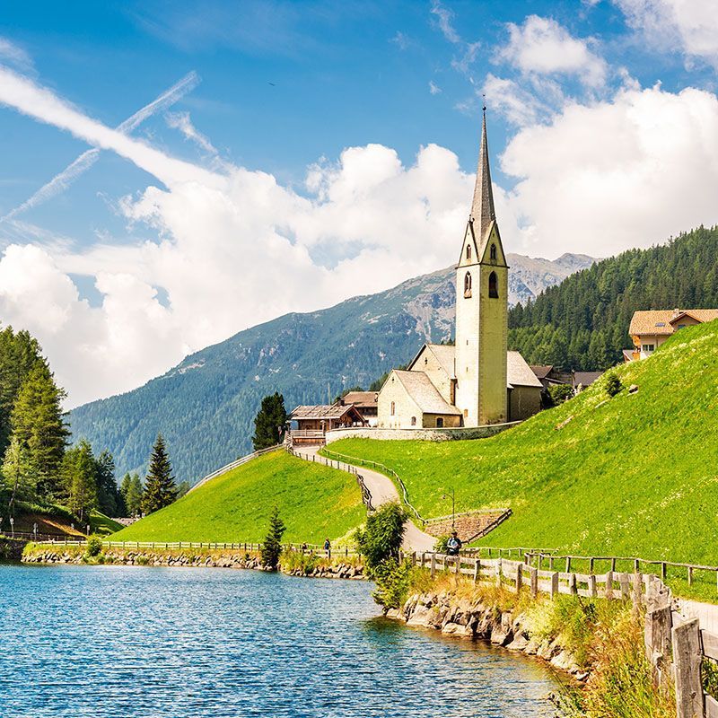
Hike to the Stone Men from Sarentino: Nature, History, and Mystery
From Bolzano, a local bus reaches Sarentino along a spectacular route of rock walls and fairy-tale castles. At the entrance to the valley you immediately spot the bulk of Castel Roncolo, and a little farther on, to the left, the ruins of Castel Sarentino – Rafenstein, while below the road you glimpse Castel Novale – Ried.
Over the first kilometers, the road tunnels through solid porphyry, and between the third and fifth you can make out the ruins of Castel Fingeller and, opposite, on a spur, Castel Vanga – Bellermont. At Ponticino the valley opens gently onto the green basin that holds Sarentino (961 m), the main town of the namesake valley and South Tyrol’s largest municipality by area.
Despite its closeness to Bolzano (19 km), the locals have proudly preserved age-old customs and traditions, thanks to the isolation that, until the 1930s, made access to the city difficult. The area is famed for local crafts such as leather embroidery with peacock feathers, work in raw wool, rugs, carved wooden items, pipes, and tobacco containers.
From the bus stop, cross a little bridge, skirt the church, and take the Peter Riegler path, then follow waymark no. 2: you’ll climb through meadows and fragrant forests, reaching the Sarentino Cabin – Sarner Skihütte (1,618 m) in about 1 hour 30 minutes. Continue to Malga Auen (1,798 m) in about 30 minutes—perfect for a stop with simple, wholesome farm fare. Crossing alpine pastures and rhododendron swathes in bloom between mid-June and mid-July, you’ll arrive at the Auen Pass – Auenjoch (1,924 m), a natural balcony with stunning views of the Ötztal Alps’ glaciers and the Dolomites.
Following waymark P, another 30 minutes bring you to the summit of Monte Schöneck (2,003 m), where you’ll find the fascinating Stone Men – Stoanerne Mandln: hundreds of small towers built by stacked stones, mentioned as early as 1540 and wrapped in the legend of being a gathering place for local witches. In this magical spot, amid silence and wind, the landscape turns surreal and invites contemplation.
The descent continues on waymark P to the Putzenkreuz (1,622 m), where there’s an inn for a well-deserved break (1 h 15). From here, take trail no. 5, which in about another hour and a quarter gently leads back to Sarentino.
- Best season: From June to October
- Insider tip: Don’t miss the rhododendron bloom from mid-June to mid-July
- Highest point: Stone Men – 003 m
- Hiking time: 5–6 hours
Hike to Monte Balzo: Between Tires, Fiè, and Spectacular Dolomite Views
From Bolzano, take a bus to Tires/San Cipriano or Fiè allo Sciliar, two ideal starting points to conquer the summit of Monte Balzo – Völsegg Spitze (1,834 m), one of the area’s most thrilling viewpoints.
If you start from San Cipriano (1,071 m), just past Tires, walk along the paved road toward the Weißlahnbad hotel; just before the hotel, on the left, take trail no. 4a toward the Tschafon hut. After about 30 minutes you’ll reach Wunleger, a small, peaceful clearing—perfect for a contemplative pause. Continue on the same path and, after another hour, arrive at the Tschafon hut (1,737 m), welcoming and scenic, where a simple, tasty meal is always a good idea.
In just 20 minutes more you’ll reach the summit of Monte Balzo, the high point of the hike, with views over the Bolzano basin, the Brenta Dolomites, the Breonie Alps, and the entire Sciliar massif—a 360° marvel.
Return along the same route (about 2 hours), or continue toward Fiè allo Sciliar to complete a loop, making the most of bus connections back to Bolzano.
Alternatively, you can start directly from Fiè allo Sciliar, near the “Bar Flora” stop, following waymark no. 1 to the hamlet of Fiè di Sopra, home to the little Church of Santa Margherita with fine frescoes. Pass the Hotel Bagni di Fieno and the Zimmerlehen residence to reach the picturesque Laghetto di Fiè in about 45 minutes—a peaceful spot perfect for a break.
Continuing along Laghetto Huber, climb to Tuff alp (1,274 m), then follow waymarks no. 1, 7, and finally 4a, always in the forest’s shade and beneath the majestic Croda del Maglio (Hammerwand), to reach the Tschafon hut in about an hour and, finally, the summit of Monte Balzo.
The route from Fiè is longer but well shaded and very comfortable. The perfect itinerary? Start in San Cipriano and finish in Fiè allo Sciliar, also taking advantage of better bus times for the return to Bolzano.
- Best season: From March to October
- Insider tip: Lush alpine bloom from May to July
- Elevation gain: Tires – 763 m / Fiè allo Sciliar – 954 m
- Hiking time: 4–5 hours (from Tires) / 6–7 hours (from Fiè).
In the Realm of King Laurin: From Nova Levante to the Catinaccio
From Bolzano, through the evocative Val d’Ega, a bus takes you to Nova Levante (1,182 m), the starting point for a hike that blends breathtaking nature, legend, and poetry. From the stop near the Tourist Association office, climb for about 30 minutes along the right bank of the Rio Larcher to the lift valley station. In a few minutes you’ll be carried first to the Frommer alp, and from there, with a second lift, to the panoramic Coronelle hut – Kölnerhütte – Rosengartenhütte at 2,339 m.
From this natural terrace, your gaze sweeps across the Dolomite groups and glaciers that embrace the Bolzano basin: the beginning of a journey into one of the Dolomites’ most enchanting places—the realm of King Laurin.
According to legend, the mighty dwarf king lived in a castle hidden among the rocks and tended a rose garden that bloomed all year. When he abducted the beautiful Künilde, sister of the Styrian hero Dietlieb, a fierce battle ensued. Defeated and stripped of his power, Laurin cast a curse: no one would ever again see his roses, neither by day nor by night. But he forgot the twilight; and precisely at that hour the mountains still glow with a fiery pink, known as enrosadira, recalling his enchanted garden.
From the Coronelle hut, trail no. 549 continues almost level, offering ever-changing views beneath the dizzying walls of the Roda di Vael. You’ll walk through a fairytale landscape, passing a large bronze eagle and a plaque commemorating Theodor Christomannos, a key figure in developing tourism in the Dolomites and promoter of the Great Dolomites Road and the famed Grand Hotel Carezza. After about 2 hours you’ll arrive at the Roda di Vael hut (2,280 m) with a spectacular view of the Marmolada, the queen of the Dolomites.
Return via trail no. 548, crossing pastures, alps, and woods to Passo di Costalunga (1,745 m), where the bus awaits to take you back to Bolzano. Along the way, you’ll skirt the romantic Lago di Carezza, an emerald-green mirror reflecting the majestic Latemar, rounding off a hike that’s far more than a simple walk—a journey into legend and the Dolomites’ absolute beauty.
- Best season: From late June to October
- Insider tip: Lush alpine bloom from May to July
- Highest point: Coronelle – 2,339 m
- Hiking time: 3.5–4 hours
Hike to the Sciliar Plateau: From Siusi into the Magic of the Highlands
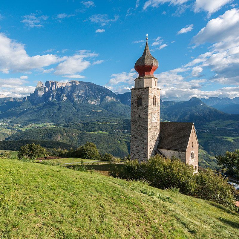
From Bolzano, take a convenient bus to Siusi allo Sciliar (998 m), a charming village at the foot of the Torre Santner and the sheer faces of the Sciliar, unmistakable symbol of South Tyrol. From the bus stop, head slightly back to the gas station, where you join trail no. 1. The climb is gradual and soon you’ll enter the Sciliar Nature Park.
One of the first stirring views appears almost immediately: set into the rock are the ruins of Castel Hauenstein, once home to the famed Oswald von Wolkenstein—poet, knight, and minstrel of the Middle Ages. After a small bridge, continue along a carriage road leading to the Bagni di Razzes hotel (1,207 m, about 1 hour).
From here, still following waymark no. 1, keep to the orographic right: the ascent—first gentle, then a bit steeper—becomes increasingly comfortable thanks to broad switchbacks leading to the Schlernbödele hut – Sciliar Plateau (1,726 m, about 1 hour 30 minutes), set in authentic, evocative alpine surroundings. A short break here is a must: with a bit of luck (or by asking the hut warden), you might spot botanical rarities such as the rock rampion or the Dolomite bellflower.
Continue to around 1,850 meters, where you’ll find a wayside-shrine junction; take trail no. 1A toward Proßliner alp (1,736 m), reached in about an hour. It’s a perfect place to stop among local dishes, lush green meadows, and postcard-worthy views.
From the alp, descend again along trail no. 1A, which requires sure footing and attention in places, especially the more exposed stretches. After passing some evocative waterfalls, cross a small valley and rejoin trail no. 1, which returns to the Bagni di Razzes hotel in about 2 hours, closing a varied, spectacular loop.
Prefer a shorter option? Choose the out-and-back from Siusi to Bagni di Razzes (total time: about 2 hours).
- Best season: From mid-May to mid-October
- Insider tip: Lush alpine bloom from May to July
- Highest point: Wayside shrine – 1,850 m
- Elevation gain: 832 m
- Hiking time: 6 hours / 4 hours (shorter option)
Hike to the Bullaccia: Panoramas, Legends, and Nature on the Alpe di Siusi
From Bolzano, a bus takes you easily to the Alpe di Siusi, Europe’s largest high-alpine plateau with its 60 km², 109 alps, 365 alpine owners, and over 3,000 grazing cattle in summer. Once there, you’re immersed in a unique setting of emerald meadows, boundless views, and crystal-clear air. From here, the hike to Monte Bullaccia follows a well-marked path that can also be shortened by using the chairlift—ideal if you prefer an easier ascent.
Past the Eurotel, follow the PU waymark winding among alps and flower-filled meadows to the Bullaccia restaurant at 2,110 m, a perfect spot for a break and to soak up the sweeping panorama. From this natural terrace, your gaze sweeps over the majestic Sassolungo and Sasso Piatto—ancient Dolomite coral atolls—the Catinaccio with its lace-like peaks, and in the distance the Marmolada, queen of the Dolomites.
Continuing along the PU/Schnürlsteig path, in about 20 minutes you’ll reach the cross at 2,104 m, with a bird’s-eye view of the Val Gardena, the Isarco Valley, and the Alpine chains of the Stubai and Zillertal. Another 15 minutes lead to the summit of Monte Bullaccia (2,176 m), home to the intriguing “witches’ chairs”: curious rock formations tied to a legend that witches once gathered here to cast their spells. Scholars believe it may once have been a pagan cult site, shrouded in a sacred aura.
The route continues with a gentle descent to the Arnica hut (2,081 m), reached in 15 minutes, then follows signs for the Bullaccia hut (1,950 m), another 40 minutes. From here, return to the Alpe di Siusi car park along a comfortable scenic carriage road (about 30 minutes) to the bus stop for Bolzano.
With a modest elevation change of 306 m (even less if you use the chairlift) and a total walking time of about 3 hours, the route is ideal from May to October, with June and July especially recommended for the alpine bloom. It’s a perfect walk for everyone—pristine nature, extraordinary views, and a dash of Dolomite mystery.
- Best season: From May to October
- Insider tip: Lush alpine bloom from May to July
- Highest point: Bullaccia – 2,176 m
- Hiking time: 3 hours (2.5 hours with chairlift)
Unforgettable Thrills and Outdoor Fun
Between sunlit plateaus, larch-lined trails, welcoming huts, and views that look painted, summer in Bolzano serves up the real thing. Every hike is an invitation to slow down, breathe deeply, and be surprised by South Tyrol’s beauty. Lace up your boots, pick your favorite route, and set off to discover these wonders just a stone’s throw from the city.